
Content block block-1903919005-1784761876
Residents in Orange County Sheriff’s Department contract cities and unincorporated areas will be able to better track public safety issues in their neighborhoods with a recently launched software program that allows them to monitor and analyze criminal activity in their area.
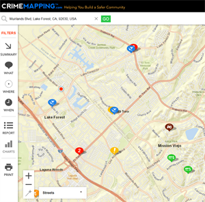
In an effort to bolster community awareness and crime prevention, the Department has partnered with TriTech Software Systems to launch CrimeMapping – an interactive application that shares crime calls.
CrimeMapping will allow residents to search for 15 types of crime by address, landmark or zip code. Residents also will be able to sign up for custom-designed alerts and can create reports to easily analyze criminal activity near their homes, schools or businesses.
“OCSD provides exemplary public safety service to some of the safest areas in the country,” said Orange County Sheriff Don Barnes. “I hope CrimeMapping encourages the community to take an even more active role in working with us to increase the safety of our neighborhoods.”
The data reflected on the mobile-friendly program is reported crimes and is updated every 24 hours. Although the information shared is preliminary, the program provides the public with important and timely information expected to increase awareness and create safer communities.
“The most common crimes our deputies respond to are crimes of opportunity - thefts from unlocked vehicles and residences,” said Undersheriff Jeff Hallock. “We hope this tool reminds the community to take the initiative to take simple steps like locking vehicles and homes to reduce access for criminals hoping to take advantage of our safe neighborhoods.”
How To Access CrimeMapping.com
Use the below links to access your city's crime data:
Aliso Viejo: https://www.crimemapping.com/map/ca/AlisoViejo
Dana Point: https://www.crimemapping.com/map/ca/DanaPoint
Harbor Patrol: https://www.crimemapping.com/map/ca/HarborPatrol_OCSD
Laguna Hills: https://www.crimemapping.com/map/ca/LagunaHills
Laguna Niguel: https://www.crimemapping.com/map/ca/LagunaNiguel
Laguna Woods: https://www.crimemapping.com/map/ca/LagunaWoods
Lake Forest: https://www.crimemapping.com/map/ca/LakeForest
Mission Viejo: https://www.crimemapping.com/map/ca/MissionViejo
Rancho Santa Margarita: https://www.crimemapping.com/map/ca/RanchoSantaMargarita
San Clemente: https://www.crimemapping.com/map/ca/SanClemente
San Juan Capistrano: https://www.crimemapping.com/map/ca/SanJuanCapistrano
Stanton: https://www.crimemapping.com/map/ca/Stanton
Unincorporated North: https://www.crimemapping.com/map/ca/OrangeCountyNorth
Unincorporated South: https://www.crimemapping.com/map/ca/OrangeCountySouth
Villa Park: https://www.crimemapping.com/map/ca/VillaPark
Yorba Linda: https://www.crimemapping.com/map/ca/YorbaLinda
CrimeMapping Mobile App
iOS users can download the CrimeMapping mobile app from the Apple App Store.
Links in this section relate to Body